Compass surveying is a straightforward method used to measure directions, angles, and locations on land using a magnetic compass. It’s particularly useful for small to medium-sized areas, assisting in boundary mapping, construction planning, and engineering projects. Here’s an overview of the basics involved in compass surveying, including concepts such as meridians, bearings, and traversing.
Table of Contents
Introduction

Compass surveying involves using a compass to measure the angle between magnetic north and a specific direction, also known as the bearing. This technique is commonly used to record the alignment of various points on land, offering a simple and efficient way to measure directions and angles in areas with visibility limitations.
Meridians
Meridians serve as directional reference points in compass surveying. The two primary types of meridians are:
True Meridian

A line from a point on the Earth’s surface to the geographic North Pole, providing a consistent reference known as true north.
Magnetic Meridian
The direction indicated by the compass needle, which aligns with the Earth’s magnetic field. Since magnetic fields can vary, magnetic meridians aren’t fixed and can change over time or with location.
These meridians provide the essential foundation for taking accurate bearings and determining directions during surveys.
Angles and Directions in Compass Surveying
In compass surveying, angles measured in degrees are used to set points relative to each other and to a reference line, generally magnetic north. The angle between the line of sight and magnetic north is called a magnetic bearing. Determining angles and directions is vital for accurately positioning points and mapping the layout of an area.
Bearing
A bearing indicates the angle between magnetic north or south and a particular line. There are two common ways to measure bearings:
Whole Circle Bearing (WCB)
Measured clockwise from magnetic north, ranging from 0° to 360° (e.g., east is 90°, south is 180°, west is 270°).
Quadrantal Bearing (QB)
In this system, bearings are measured from either north or south towards east or west, within a 90° range (e.g., northeast would be N30°E, southwest as S40°W).
Interior Angles

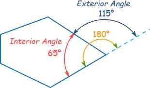
Interior angles are angles within a closed shape formed by a traverse or a survey path. These angles are vital for adjusting and verifying the accuracy of surveys and are often used in calculating the area of irregularly shaped plots.
Types of Compasses in Surveying
There are different types of compasses used in surveying, each offering specific features based on the level of precision needed:
Prismatic Compass
This compass has a prism for magnifying the reading, allowing for more precise bearing measurement. It is commonly used for standard surveying tasks due to its accuracy.
Surveyor’s Compass
Often used in large-scale surveys, this compass has settings that allow for improved accuracy and effective angle measurement.
Magnetic Compass
A simple compass with a magnetic needle pointing toward magnetic north, mainly for basic directional surveys that do not require high precision.
Using a Prismatic Compass
The prismatic compass is a popular tool in compass surveying, valued for its accuracy and simplicity. It features a prism that magnifies degree readings, making it easier to take accurate measurements. It also has a sighting vane for precise alignment with an object.
Steps for using a prismatic compass:
Set the compass on a tripod or hold it firmly at the starting point.
Align the compass with the target object.
Read the bearing through the prism to record the angle.
The prismatic compass is especially useful in smaller surveys for its portability and precision.
Traversing in Compass Surveying
Traversing involves creating a route or pathway between points by measuring distances and angles. In compass surveying, a traverse can be classified as:
Open Traverse
Starts at one point and ends at another without forming a closed loop, often used for surveying linear features such as roads or pipelines.
Closed Traverse
Forms a complete loop, enabling verification of survey accuracy, as the end point should align with the start.
Traversing helps define boundaries, map routes, and connect various survey points accurately.
Local Attraction
Local attraction is the magnetic disturbance that can impact compass readings, creating errors in direction measurement. This interference might stem from nearby metal objects, electrical equipment, or even natural magnetic materials in the area. To correct for local attraction, surveyors may compare readings taken from multiple locations and make adjustments to improve accuracy.
Plotting a Traverse
Plotting a traverse means transferring measured angles and distances onto paper to create a map. This involves setting the starting point, drawing lines at each recorded bearing, and marking distances. Plotting provides a clear visual layout of the surveyed area.
Steps in plotting a traverse:
Establish the starting point and mark it on the map.
Draw lines at recorded bearings using a protractor or plotting tool.
Measure and plot distances between each point, maintaining scale accuracy.
Plotting allows surveyors to create a visual representation of the land, essential for project planning and documentation.
Conclusion
Compass surveying is a practical technique for measuring directions and locations on land, making it a fundamental method in surveying. With tools like the prismatic compass, surveyors can efficiently measure bearings and angles to map out traverses, define boundaries, and plan routes. By understanding meridians, bearings, local attraction, and plotting, compass surveying provides valuable data for construction, land management, and engineering projects.
Frequently Asked Questions(FAQ)
What are interior angles, and why are they important?
Interior angles are the angles formed within a closed shape by the survey lines. They are essential for checking and adjusting survey accuracy, particularly in closed traverses, and for calculating the area of irregular plots.
How is a prismatic compass used?
The prismatic compass has a prism to magnify the bearing reading, along with a sighting vane for alignment. It’s simple and portable, making it ideal for small-area surveys. To use it, set it up at a point, align with the target, and read the bearing through the prism.
Related Articles

